Rank : 10.0 (average on 2 votes)Coordinates : 36.781036, -112.061419 (
Open in Google Maps)
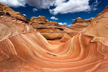
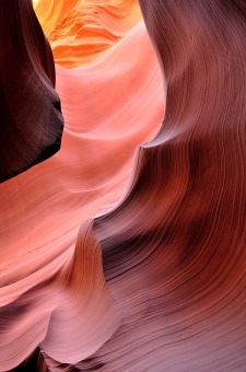
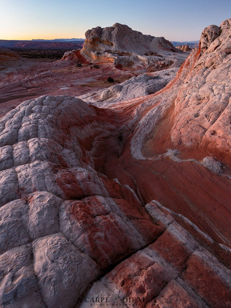
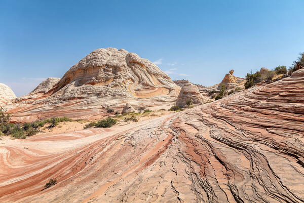
Subjects : You an see many sandstone wonders of the American Soutwest. The Wave is here, as well as White Pocket. It is hard to actually get here, because often times you need a 4x4 vehicle. But in the end it is well worth the effort.
Recommended equipment : Any camera will do, but wide angle is recommended. Also it is quite sandy so protect your gear.
Best months : Year round the place is amazing
How to get there : Directions to White Pocket From Kanab, drive 40 miles east on Highway 89. The turn onto House Rock Valley Road is located on the south side of the road (right side driving from Kanab). It is located between mile markers 25 and 26, before a sweeping left hand curve in the road, prior to a guard rail protecting the curve. Slow down and turn right just before the guard rail. This north-south running road is House Rock Valley Road. The road soon becomes dirt and may be impassible if wet. Continue past the Wirepass Trailhead (8.4 miles from Highway 89) to the Utah - Arizona state line. This is the border of the Grand Staircase-Escalante National Monument in Utah and the Vermillion Cliffs National Monument in Arizona. Keep driving south for another 8.1 miles past the Wire Pass Trailhead and look for the dirt road that turns left and to Lone Tree Reservoir. At this point there are two options to arrive at Poverty Flat. Poverty Flat is the junction to the east which is necessary to locate to continue further to either Cottonwood Spring (South Coyote Buttes) or White Pocket even further to the east.Turn left at Lone Tree Reservoir and follow the main, sandy 4WD road to the east for 2.5 miles to the Paw Hole trailhead. Beyond Paw Hole the road becomes even deeper sand and may require tire deflation to prevent becoming stuck. The next 3 miles to the Windmill at Poverty Flat Ranch is deep sand and quite rugged in places. The road will pass through two gates. Close the gates after passing through them.(Alternative route to the Poverty Flat Ranch and Windmill Intersection: At the Lone Tree Reservoir/ House Rock Valley Road Intersection you may opt to continue another 4 miles to the south on House Rock Valley Road to the road intersection 1017. Turn left (east) on 1017 and then travel 3 miles east to the junction bearing north-east and another 3 miles to Red Pocket. Traveling north-east for another 2.5 miles puts you at the Ranch and Windmill, and the junction to either Cottonwood Spring or White Pocket. This option of driving is longer, but does not require 4WD until after the Windmill.)Once at the Windmill, travel northeast passing the windmill just on your left and a group of buildings on your right. The road now becomes quite sandy as it ascends a hill, toward a large water tank resting on a knoll 100 yards away. Be sure to keep up momentum and follow this sandy road to the east and then north for 1.8 miles until it arrives at a corral and fence. At this point the road will turn right and follow alongside the fence for a short time and continues east for 2.8 miles and then steers northeast for another 1.5 milesand ends in a very sandy area by a lone juniper tree. This is the parking area and trailhead. "White Pocket" monolith will have been visible during the drive at various times, and at the trailhead/parking area it is just a half mile to the west.There is no formal trail established, but it will soon be evident that wandering and exploring is the main fare. Immediately from arriving, and walking toward "White Pocket" the slickrock formations will lure and amaze with the unique colors and texture. Take time to look over the extensive formations and then maybe drop down into the valley below and head for a circumnavigation of the "White Pocket" monolith to the west? There is much to see, but remember to tread lightly and preserve the landscape as you found it.
Visits : You need to rent a very good 4x4 jeep or already have one
Notes :
CalendarSunrise: 05:12, Sunset: 19:51
Show Sunrise and Sunset Calendar DiscussionNo replies
Read the discussion Moon Phase🌕 Full Moon,
Brightness: 99%
Show Moon Phases Calendar 
 JuzaPhoto contains affiliate links from Amazon and Ebay and JuzaPhoto earn a commission in case of purchase through affiliate links.