RCE Foto

(i) On JuzaPhoto, please disable adblockers (let's see why!)


Login LogoutJoin JuzaPhoto!
JuzaPhoto uses technical cookies and third-part cookies to provide the service and to make possible login, choice of background color and other settings (click here for more info).

By continuing to browse the site you confirm that you have read your options regarding cookies and that you have read and accepted the Terms of service and Privacy.


OK, I confirm


You can change in every moment your cookies preferences from the page Cookie Preferences, that can be reached from every page of the website with the link that you find at the bottom of the page; you can also set your preferences directly here

Accept CookiesCustomizeRefuse Cookies

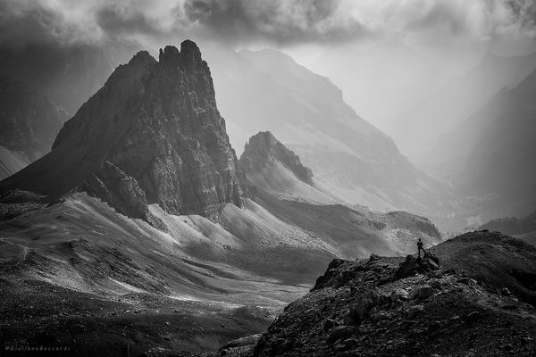
Monte Thabor, France


cover photo by Giulianophoto  


Location added by Stefano Gall


 The information about this location have been automatically translated with Microsoft Translator.

Rank : 7.5 (average on 2 votes)

If you know this place, give your vote:  

Coordinates : 45.114022, 6.563867 (Open in Google Maps)

Subjects : The type of photograph of this place is mainly landscape and wildlife. The characteristic features of the place are the mountain ranges of the Hautes Alpes, lakes, glaciers and several vallate.La end of the path is represented by a particular note church with the name of Chapel of Our Lady of Seven Sorrows, which can also be used as a shelter night for those wishing to photograph the sky and the stars.

Recommended equipment : Mostly wide-angle lenses for paesaggistica.Zoom for fauna.Treppiedi for night photography.

Best months : All the year; both summer and winter both.

How to get there : The journey lasts about 5 hours, you can climb to the summit starting from the Valle Stretta and passing by the Third Alpini Refuge, near which you can leave the car. Continue along the dirt road to the foundry floor and from there proceed to the left always following the dirt road up to the old iron mines of Banchet. After the mine, with a short climb you get to 2,200 meters above sea level at the Planche bridge, then passed the stream, climb along the Vallone of Desinare at the base of Grand Seru. The trail follows a stretch the left bank of a small stream that runs through after reaching a plateau ;, from here you proceed on a rocky path in a series of coils that are rapidly gain altitude and then on the plains, in the direction of Chapel of Our Lady of Seven Sorrows, now clearly visible, located near the summit of Mount Tabor at 3,178 meters above sea level. Terzo Alpini refuge from the travel time is about four hours. Degree of difficulty E. The drop is 1,450 m. (Cit. From Wikipedia)

Visits : Admission is free and there are no specific times to go to, it is a path that you can face the day and night, summer and winter.

Notes :


Calendar

Sunrise: 06:28, Sunset: 20:34

Show Sunrise and Sunset Calendar
Discussion

No replies

Read the discussion
Moon Phase

🌖 Waning Gibbous, Brightness: 94%

Show Moon Phases Calendar
Nearby:

Destinazione
Lac Vert - Nevache
6 km
Destinazione
Nevache
10 km
Destinazione
Bardonecchia
12 km
Destinazione
Colle del Galibier
14 km
Destinazione
Valle della Claree
18 km
Destinazione
Mont Chaberton
22 km


Photos taken at Monte Thabor


Sort by popularitySort by date

Foto
The man and the rock
by Giulianophoto
3 comments, 717 views  [retina]
Foto
Mount Tabor
by Alessandro Ceresole
0 comments, 651 views  [retina]


More » Locations » France » Monte Thabor


 ^

JuzaPhoto contains affiliate links from Amazon and Ebay and JuzaPhoto earn a commission in case of purchase through affiliate links.

Mobile Version - juza.ea@gmail.com - Terms of use and Privacy - Cookie Preferences - P. IVA 01501900334 - REA 167997- PEC juzaphoto@pec.it

May Beauty Be Everywhere Around Me